
Agricultura di Avezzano in Palazzo Torlonia

All photography work is copyrighted by the author, please don't download and publish these pictures in the internet without my permission!
Larger high quality pictures is available only for donators up on request! Vasileios Papaidis 2018 © All Rights Reserved
Avezzano,Povince of L'Aquila,Abruzzo,Italy
53 km from L'Aquila, 60 km from Rome lies the main commercial, industrial and agricultural centre in Marsica. But also technology has its place, with the astronomical observatory of Telespazio, one of the leaders in satellite communications, and the huge Micron Technology plant. Once on the brink of the largest lake in central Italy, the territory shows traces of the first attempts to drain the unhealthy basin: the remains of Roman walls are still extant along the riverbed of an artificial effluent. After the 1915 earthquake the town was completely rebuilt along straight, parallel streets, with wide green areas and fine liberty villas.
History
There are two common ethimologies for the name of the town: from "Ave Jane", an invocation to the Roman God Janus and from "Ad Vetianum" which means a "to the Vetia family", domiciled in the town of Alba Fucens. The first settlements in this area began with the construction works for the lake's drainage ordered by Emperor Claudius in the first century A.D. In the XV century Avezzano was under Gentile Virgilio Orsini, who built the castle in 1490. In the late XIX-early XX century the town, after the draining of Lake Fucino, underwent a terrific growth, but was completely destroyed in the famous earthquake of the morning of January 13: only Casa dei Palazzi and a wing of Castle Orsini were spared. More destruction was caused by air bombings in 1944. A few km away lies a celebrated archaeological site, Alba Fucens, founded in 304 B.C., once the centre of a powerful civilization, now an impressive desert of white ruins.
Sights & Excursions
-
Orsini Castle, with its fine XVI-century portal
-
Church of St.Giovanni
-
Museo Lapidario, with remains from Alba Fucens, Ortona dei Marsi and Marruvium
-
Incile, south of Avezzano, where the construction of the Torlonia emissary began, not far away from the "cunicoli di Claudio", the original tunnels for the draining of the lake in Roman times, can still be walked.
-
Alba Fucens
-
Mount Velino
-
Parco Nazionale d'Abruzzo
Fucine Lake
Max. length17.28 km (10.74 mi)
Max. width10.85 km (6.74 mi)
Surface areamax 140 km2 (54 sq mi)
Surface elevation661 m (2,169 ft)
The Fucine Lake (Italian: Lago Fucino or Lago di Celano) was a large endorheic lake in central Italy, stretching from Avezzano in the northwest to Ortucchio in the southeast, and touching Trasacco in the southwest. Once the third largest lake in Italy, it was drained in 1877.
The former lake is mentioned by Virgil in the Aeneid in book 7, in that it weeps for Umbro, the healer priest killed tragically in battle.
Roman Drainage
The Romans knew the lake as Fucinus Lacus and founded settlements on its banks, including Marruvium. It was the site of the Battle of Fucine Lake in 89 BC. However, while the lake provided fertile soil and a large quantity of fish, it was also believed to harbour malaria, and, having no natural outflow, repeatedly flooded the surrounding arable land. The Emperor Claudius attempted to control the lake's maximum level by digging a 5.6 km (3.5 mi) tunnel through Monte Salviano, requiring 30,000 workers and eleven years, but with uncertain success.
Of the collapse of one of the tunnels Cassius Dio observed
"When the Fucine Lake caved in, the prominent freedman Tiberius Claudius Narcissus was severely blamed for it. For he had been in charge of the undertaking, and it was thought that after spending a good deal less than he had received he had then purposely contrived the collapse, in order that his wrong-doing might not be detected."
The original lake had a fluctuating area of about 140 km2 (54 sq mi) which the Claudian initiative may have reduced to about 90 km2 (35 sq mi). A 4.5 km (2.8 mi) collecting canal was extended and deepened by Hadrian which reduced the area of the lake to about 57 km2 (22 sq mi). The larger 19th century tunnel, along the same route as the Roman tunnel, destroyed most of the archaeology of the Roman tunnel, which is why the success of the earlier Claudian scheme is so uncertain. The deeper Hadrianic canal destroyed the archaeology of the Claudian canal. The final Roman canal has left clear archaeology, showing that 1 km (0.62 mi) from the lake, the tunnel was 7.5 m (25 ft) deep, 19.5 m (64 ft) wide at the top, and 4.5 m (15 ft) wide at the base. It sloped to the tunnel at 0.05% (a gradient of one in twenty). A very detailed account of the Roman scheme is found in the Brisse & Retrou reference below.
Drain blockage
As the Empire fell, there was a failure to maintain the Roman drainage scheme. Sediment and vegetation blocked the collecting canal. An earthquake on a fault crossing the collecting canal dropped the land on the lake side 30–35 cm (12–14 in) relative to the tunnel entrance. Investigations where the fault crosses the canal show that large amounts of sediment had accumulated in the canal before the earthquake. On the assumption that this earthquake would damage Rome it seems very likely that the earthquake occurred shortly before 508 AD when the earthquake damage to the Colosseum was repaired. The lake appears to have returned to its uncontrolled pre-Claudian area by the end of the 5th century and certainly by the end of the 6th century.
Some suggestion, or attempt, to restore the Roman drainage scheme appears in both the 13th and 15th centuries but neither succeeded.
New Drainage
In the 19th century, the Swiss engineer Jean François Mayor de Montricher was commissioned by the prince Alessandro Torlonia to drain the lake. A 6.3 km-long (3.9 mi) and 21 m-wide (69 ft) canal was begun in 1862 and after more than 13 years, the lake was completely drained. The resulting plain is one of Italy's most fertile regions. Antiquities from the Roman occupation of the land, after the first drainage scheme, became part of the Torlonia collection.

Palazzo Torlonia is a historic building in Avezzano in Abruzzo, located in an area of the city center adjacent to the homonymous square. The original palace, built in the second half of the nineteenth century, was almost completely destroyed with the earthquake of 1915. The palace was reconstructed by the Torlonia and was inaugurated in 1925.
Photo Gallery
 |  |  |
|---|---|---|
 |  |  |
 |  |  |
 |  |  |
 |  |  |
 |  |  |
 |  |  |
 |  |  |
 |  |  |
 |  |  |
 |  |  |
 |  |  |
 |  |  |
 |  |  |
 |  |  |
 |  |  |
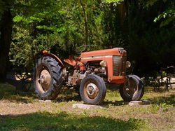
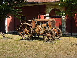
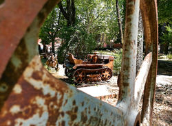
With the drainage of the lake, the flourishing of rural development has helped the population find work and deal with the cultivation of land, but there are big questions about what would happen if the lake existed and the local rulers helped develop it like tourist resort...
These time-worn agricultural machinery are there to remind us that mistakes of the past should not be repeated in the future.
The images are exclusive as I am a step beyond simple motoring, after a special permit granted to me by the authorities of the city of Avezzano.
Vasileios Papaidis


